
(*) Gigantes Island Destinations Map: Norte, Sur, Offshore Islets, and Sicogon
Understand the Gigantes Island destinations by geographic cluster, including Gigantes Norte, Gigantes Sur, offshore islets, Sicogon, and route access.
[ADS]
* Book Now, Pay Reservation Later, Balance on Your Tour Date. Terms and Conditions Apply. Subject to Availability.
Gigantes Island destinations are distributed across two principal inhabited islands—Gigantes Norte and Gigantes Sur—plus separate offshore islands, islets, sandbars, beaches, and the wider Sicogon area. They are not neighborhoods of one continuous resort island, and most cannot be reached simply by walking from one attraction to another.
This geography explains why different tours include different combinations of stops. A boat route focused on Cabugao Gamay, Bantigue Island and Sandbar, and Tangke Lagoon is different from a land-oriented visit to the Century-Old Lighthouse on Gigantes Norte or a wider trip to Sicogon Island. Time spent moving between these clusters forms a meaningful part of the travel day.
The official Carles Tourism display features 13 destinations, but the list should be understood as a destination framework rather than a standard one-day itinerary. Access depends on the confirmed package, boat operator, tides, wind, waves, daylight, trail conditions, property rules, maritime clearance, and the captain’s safety decision.
How to Read a Gigantes Island Destinations Map
A useful geographic map should separate four general route areas:
- Mainland Carles and Bancal Port
- Gigantes Norte
- Gigantes Sur
- Offshore islands, islets, sandbars, and the separate Sicogon cluster
Bancal Port in Barangay Bancal is the official entrance and exit point and gateway to the island destinations of Carles under Municipal Ordinance No. 2016-03. Travelers normally complete the current tourism procedures and Tourism Pass arrangements through the Bancal Tourism Office before boarding an authorized trip.
A destination map should show boat connections rather than suggesting that all attractions are connected by roads. It should also identify the likely base island or route cluster for each stop while warning that the actual landing point can change according to sea conditions and current operating arrangements.
| Geographic Cluster | General Character | Typical Access Consideration |
|---|---|---|
| Mainland Carles and Bancal | Tourism registration, road transfers, supplies, and boat departures | Travelers must reach the correct reporting and boarding area. |
| Gigantes Norte | Island communities, caves, heritage areas, and the lighthouse | Some stops require a landing followed by local land transportation or walking. |
| Gigantes Sur | Beaches, Tangke Lagoon, inland trails, farms, and viewpoints | Marine and land stops may be combined in operator-defined routes. |
| Offshore islets and sandbars | Cabugao islands, Bantigue, Ojatras, Balbagon, and other small stops | Each is a separate boat destination with tide- and weather-dependent landings. |
| Sicogon cluster | Beaches, communities, Mt. Opao, Tumaquin Islet, and nature trails | The wider route requires additional boat time and separate access checks. |
Geographic Differences Between Gigantes Norte and Gigantes Sur
Gigantes Norte
Gigantes Norte is one of the principal inhabited islands in the group. It is associated with island communities, caves, local land routes, and the historic lighthouse area. The official Carles Tourism display identifies the Century-Old Lighthouse as a featured destination and states that it was constructed in 1895.
A lighthouse visit should not be confused with a standard beach landing. Travelers may need to arrive through a community landing point, arrange local transportation, and walk over uneven or exposed ground. The package should explain whether the guide, local ride, entrance arrangements, and return boat are included.
Caves on or around Gigantes Norte may appear in locally arranged or operator-defined itineraries, but they are not all part of the official 13-destination display. Cave access should occur only with current local permission and an approved guide where required. Flooding, wildlife protection, unstable rock, darkness, or access restrictions can make a previously promoted cave unavailable.
Gigantes Sur
Gigantes Sur is commonly associated with Tangke Lagoon, beaches, island communities, inland paths, farms, and viewpoints. Operator-defined Tour B products may combine boat stops with locations such as Pahuwayan Landscape, the Dragon Fruit Farm, a viewpoint, or another managed land attraction.
These additional land stops should not be described as standardized official Tour B inclusions. Access may depend on private-property rules, opening hours, local coordination, trail condition, season, and weather.
Travelers should ask how much walking is involved and whether the route includes steep steps, exposed viewpoints, muddy paths, or limited railings. A marine-focused traveler may prefer a shorter boat route, while guests interested in community and inland scenery may choose a package with fewer offshore stops.
Cabugao, Bantigue, Ojatras, and Other Separate Offshore Stops
Cabugao Gamay, Cabugao Dako, Bantigue Island, Ojatras Island, and Balbagon Island are separate offshore destinations. They are not sections of Gigantes Norte or Gigantes Sur that travelers can reach by walking from one another.
Cabugao Gamay Island
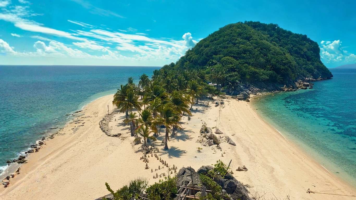
Cabugao Gamay is the best-known photographic landmark in the Gigantes group. The official tourism display calls it the “selfie island” and highlights the elevated viewpoint over the islet and surrounding waters.
The climb can be steep, crowded, windy, and slippery. Viewing time may be limited when several boats arrive together. Visitors should keep pathways clear, secure phones and hats, and use only the approved climbing route.
Cabugao Dako Island
Cabugao Dako is a separate neighboring island known for its white-sand beach and blue water. Its inclusion should not be assumed merely because Cabugao Gamay appears in the package.
The operator should clarify whether the tour includes a landing, a pass-by, or a substitution stop. Beach width, water clarity, swimming conditions, and landing arrangements vary with tide, season, and weather.
Bantigue Island and Sandbar
Bantigue Island and Sandbar is known for its long, creamy-white sandbar. Its curve, exposed area, and walking space change throughout the day. At higher tide, portions can be narrow or submerged.
The sandbar is an evolving coastal feature rather than a fixed structure. Visitors should remain within the area identified by the guide, avoid boat channels, and never collect sand, shells, stones, or marine organisms.
Ojatras Island (Pulupandan)
Ojatras Island is also identified in tourism materials as Pulupandan and is sometimes written online as Pulo Pandan. These naming variations can confuse travelers comparing packages, so the itinerary should use both the official and familiar names where useful.
It is a small islet known for pale sand and turquoise water. Shade, toilets, food, and other facilities should not be assumed. Ask whether the tour includes an actual landing or only a scenic pass-by.
Balbagon Island
Balbagon Island is an elongated island near the Pulo Pandan area and may appear in extended, alternative, or operator-defined routes. It is not one of the 13 destinations featured in the official Carles Tourism display.
A Balbagon inclusion should state whether it is a primary landing, alternative beach, or scenic pass-by. Reaching it adds boat travel, which may reduce the time available at other attractions. Its shoreline can be exposed, hot, windy, and affected by changing landing conditions.
Using the Official 13-Destination Framework Without Overpromising
The official Carles Tourism destination framework includes:
- Tangke Lagoon
- Cabugao Gamay Island
- Cabugao Dako Island
- Bantigue Island and Sandbar
- Antonia Point
- Ojatras Island (Pulupandan)
- Mini Boracay (Calumpang)
- Tinagong Bay-Bay (Dakong Bay-Bay)
- Century-Old Lighthouse
- Sicogon Island
- Tumaquin Islet
- Mt. Opao
- Sicogon’s Lagoon Eco-Trail
This list presents the range of tourism destinations across Carles. It is not a promise that all 13 places can be visited in one day, one package, or even one route cluster.
Tangke Lagoon, Cabugao Gamay, Bantigue Island and Sandbar, and Antonia Point may appear in marine-focused itineraries. The Century-Old Lighthouse requires a Gigantes Norte land arrangement. Mt. Opao is a hike on Sicogon, while Tumaquin Islet and Sicogon’s Lagoon Eco-Trail require their own access checks.
Travelers should use the complete Gigantes Island attractions guide to compare the official stops, physical demands, naming variations, and environmental requirements.
Sicogon as a Separate Destination Cluster
Sicogon is part of Carles but forms a separate island cluster from the principal Gigantes routes. It consists of the barangays of Alipata, Buaya, and San Fernando, with beaches, accommodations, trails, communities, and landing points dispersed around the island.
A combined Gigantes–Sicogon tour may operate on selected dates or when a shared group reaches the required minimum. Because the route is wider, it may depart earlier and include fewer stops in each area.
Tumaquin Islet
Tumaquin Islet may appear close to Sicogon and can be separated by shallow water under certain tidal conditions. Visitors must follow local guidance because the route can become covered as the tide rises, and currents can change.
Mt. Opao
Mt. Opao is a substantial hiking attraction rather than a quick beach stop. A visit requires an early start, a knowledgeable guide, suitable footwear, adequate water, stable weather, and enough daylight for the return.
Sicogon’s Lagoon Eco-Trail
The Lagoon Eco-Trail is a nature-based attraction whose current access, fees, guide requirement, trail condition, and operating schedule must be confirmed before travel.
Travelers considering this cluster should read the Sicogon Island visitor guide before combining it with a standard Gigantes route.
Boat Travel Time and Better-Paced Route Clusters
Boat travel between Gigantes Island destinations consumes a meaningful part of the day. Moving from Bancal to the Gigantes area, traveling between offshore stops, entering a lagoon, landing at beaches, and extending the route toward Sicogon all require time.
Wind and waves may force the captain to reduce speed or use a safer route. Passenger boarding, wet landings, crowding, meals, and repeated loading also affect the schedule.
A package should therefore be compared by actual tour time rather than the number of names in the advertisement. A shorter route with well-spaced stops can provide:
- Safer and less rushed boarding
- More time for swimming or photographs
- A proper meal break
- Less pressure on children and older travelers
- More flexibility when one landing is delayed
- A safer return before daylight becomes limited
Tour A, Tour B, and combined Sicogon products are not standardized. Ask which attractions are full landings, short stops, pass-bys, hikes, or alternatives. Compare the practical route through the Gigantes Island tour guide.
Choosing an Overnight Base According to the Route
Overnight travelers should choose their base according to the next day’s confirmed route—not merely the most attractive room photo. Moving between mainland Carles, Gigantes Norte, Gigantes Sur, and Sicogon may require a chartered or scheduled boat that is not included with the accommodation.
| Overnight Base | Potential Advantage | Important Transfer Question |
|---|---|---|
| Mainland Carles | Road access, supplies, and easier Bancal reporting | How long is the early transfer to the exact registration area? |
| Gigantes Norte | Useful for community, cave, or lighthouse-oriented plans | Which landing point and local transport are included? |
| Gigantes Sur | Useful for selected southern marine and land attractions | Does the room include the correct boat transfer? |
| Sicogon | Useful for Sicogon beaches, trails, or resort areas | Which barangay and landing point serve the property? |
A room reservation does not automatically include transportation to the next island. Confirm the boat operator, departure time, baggage allowance, landing point, and weather policy before paying. The Gigantes Island hotels guide explains mainland and island accommodation differences.
Confirming Public, Community, Private, and Restricted Access
Destination pages and tour listings should explain how each place is managed, but access classifications can change. Travelers should confirm whether a destination is currently:
- Open through an organized tour
- Community-managed
- Privately or resort-managed
- Subject to an entrance or day-use fee
- Seasonally restricted
- Closed because of weather, maintenance, wildlife, or safety
- Accessible only with a guide or prior permission
A beach near a resort does not automatically include access to private facilities. A community landing does not automatically permit visitors to enter homes, farms, trails, or working areas. Ask before using toilets, pathways, docks, or other facilities.
Environmental Protection Across All Destination Clusters
Visitors must not collect or remove sand, pebbles, rocks, shells, coral, plants, wildlife, or other natural resources. The prohibition applies to beaches, sandbars, caves, lagoons, trails, offshore islands, and marine areas.
Responsible visitors should:
- Remain within approved landing, swimming, and walking areas.
- Avoid standing on coral or chasing marine wildlife.
- Keep away from working boats, nets, ropes, and engines.
- Carry all waste to an appropriate disposal point.
- Keep noise low near homes, caves, and wildlife habitats.
- Ask permission before photographing residents or private property.
- Follow the captain, guide, tourism office, and local authorities.
Gigantes Island Destinations Planning Checklist
- Identify whether each stop is on Norte, Sur, an offshore island, or Sicogon.
- Do not assume similarly named places are within walking distance.
- Use the official 13 destinations as a framework, not a one-day promise.
- Distinguish official destinations from operator-defined additions.
- Ask which stops are landings, hikes, pass-bys, or alternatives.
- Compare actual boat time and route spacing.
- Confirm tide, weather, trail, property, and maritime restrictions.
- Choose an overnight base according to the next confirmed route.
- Verify whether inter-island transfers are included.
- Check whether access is public, community-managed, privately managed, or restricted.
- Accept the captain’s final authority over the safe route.
- Leave all natural resources undisturbed.
Book your Gigantes Island hopping experience at GigantesIsland.com/book, or visit GigantesIsland.com/frequently-asked-questions to learn more.
