
(*) Gigantes Island Attractions: Official 13 Destinations and Additional Tour Stops
Explore the official Gigantes Island attractions, additional tour stops, physical requirements, tide conditions, route limits, and environmental rules.
[ADS]
* Book Now, Pay Reservation Later, Balance on Your Tour Date. Terms and Conditions Apply. Subject to Availability.
Gigantes Island attractions are spread across Gigantes Norte, Gigantes Sur, Sicogon Island, and several nearby islands, islets, beaches, sandbars, and marine areas. This geography is important because the destination is not one continuous resort island where every landmark can be reached by road or on foot. Most sightseeing requires organized boat travel, while certain viewpoints, caves, farms, and trails require separate land access.
The official Carles Tourism display features 13 destinations, but the list is not a guaranteed one-day itinerary. Tour A, Tour B, private trips, and combined Sicogon routes are operator-defined products whose actual stops vary by provider and travel date. Tides, weather, trail conditions, crowd controls, private-property rules, maritime clearance, daylight, and passenger safety can all affect access.
Before paying, request the exact itinerary in writing and verify the current operating provider. Travelers normally complete the required tourism procedures and Tourism Pass arrangements through Bancal Port before proceeding to authorized island destinations. The Bancal Port guide explains the official gateway, registration, boarding, and departure procedures.
Official Carles Tourism Destinations Grouped by Island and Area
The 13 officially featured destinations can be understood more easily when grouped by their general location and type of experience.
| Area or Route Cluster | Official Destination | Typical Experience | Likely Physical Demand |
|---|---|---|---|
| Gigantes marine route | Tangke Lagoon | Saltwater lagoon enclosed by limestone or karst cliffs | Boat transfer, wet surfaces, and condition-dependent access |
| Offshore island stop | Cabugao Gamay Island | Beach, elevated viewpoint, and panoramic photographs | Steep steps, sun exposure, crowding, and limited space |
| Offshore island stop | Cabugao Dako Island | White-sand beach and swimming area | Possible wet landing and exposed shoreline |
| Offshore island stop | Bantigue Island and Sandbar | Tide-shaped sandbar and open coastal scenery | Walking on wet sand with little shade |
| Gigantes marine route | Antonia Point | Beach and layered stone formations | Beach landing, swimming, and uneven coastal surfaces |
| Offshore islet | Ojatras Island (Pulupandan) | Small-islet scenery, pale sand, and turquoise water | Short exposed landing with limited facilities |
| Additional marine stop | Mini Boracay (Calumpang) | Fine white sand, foliage, and rock formations | Boat landing and open sun exposure |
| Additional beach stop | Tinagong Bay-Bay (Dakong Bay-Bay) | Small white-sand beach area | Condition-dependent beach access |
| Gigantes Norte | Century-Old Lighthouse | Historic lighthouse and land-based heritage stop | Walking, possible uneven ground, and heritage-site restrictions |
| Sicogon area | Sicogon Island | Beaches, communities, vegetation, trails, and resort areas | Depends on the selected beach, barangay, or managed property |
| Sicogon area | Tumaquin Islet | Small-islet visit with tide-sensitive access | Shallow-water or boat access under local guidance |
| Sicogon area | Mt. Opao | Mountain hike and elevated island views | Substantial hiking, heat, slopes, and changing trail conditions |
| Sicogon area | Sicogon’s Lagoon Eco-Trail | Nature trail and lagoon environment | Walking on potentially wet, muddy, or uneven paths |
Tangke Lagoon
Tangke Lagoon is a saltwater lagoon enclosed by limestone cliffs. It is one of the most recognizable Gigantes Island attractions, but its appearance and accessibility change with the tide, sea conditions, and the safest available transfer method.
Promotional photographs may show calm, clear water and a spacious swimming area, but these conditions are not constant. Water level, waves near the entrance, crowding, and boat position can affect whether visitors can enter or how long they may remain.
Passengers should follow the crew’s instructions, keep both hands available during transfers, and avoid climbing or touching limestone formations. Secure sandals or water shoes provide better control than loose slippers on wet surfaces.
Cabugao Gamay Island
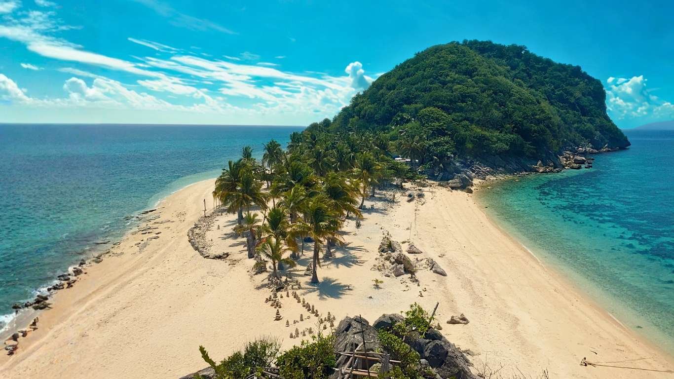
Cabugao Gamay is identified in the official tourism display as the “selfie island.” Its narrow beach and elevated viewpoint make it one of the destination’s most photographed stops.
The viewpoint climb can be steep, exposed, crowded, and slippery. Visitors should use the approved path, keep the steps clear, secure phones and hats, and follow any time limits imposed when several boats arrive together. The limited space at the top is not suitable for rushing, pushing, or stopping for extended photo sessions.
Swimming should be limited to the guide-approved area because depth, rocky sections, currents, and boat traffic can vary around the island. Viewing time and access depend on the day’s route and should never be treated as guaranteed.
Cabugao Dako Island
Cabugao Dako is officially described as having a white-sand beach and clear blue water. Its actual beach width, water clarity, swimming conditions, and landing area vary with the tide, weather, season, and sea state.
A boat may land directly on the beach or require passengers to step into shallow water. Keep cameras and phones protected until safely ashore, and wear footwear that will remain secure in the water.
Cabugao Dako and Cabugao Gamay are separate islands. A package should not be assumed to include both merely because it uses the word “Cabugao.”
Bantigue Island and Sandbar
Bantigue Island and Sandbar is known for a long, creamy-white stretch of sand whose shape and exposed walking area change with the tide. At higher water levels, part of the sandbar may be submerged, narrower, or unavailable for the type of photographs shown online.
The sandbar offers little natural shade, so visitors should bring water and secure sun protection. Remain within the area identified by the guide because currents, channels, and approaching boats may be present beyond the shallow section.
Water shoes or strapped sandals are more practical than loose slippers. Visitors must not collect sand, shells, stones, coral fragments, or marine organisms.
Antonia Point
Antonia Point is often marketed as Antonia Beach. The official name helps distinguish the destination from similarly named accommodations or package descriptions. It is known for white sand and layered stone formations that are sometimes compared with stacked boulders or slices of bread.
Swimming and recreational water activities may be offered depending on local authorization, equipment, weather, and operating arrangements. Ask which activities are included and whether separate fees apply.
Visitors should avoid climbing unstable formations, entering unapproved water areas, or blocking access used by boats and other groups.
Ojatras Island, Pulupandan, and Pulo Pandan
Ojatras Island is also identified in tourism materials as Pulupandan and is commonly written online as Pulo Pandan. These naming variations may refer to the same small-islet stop, but travelers should verify the operator’s exact itinerary rather than relying only on the spelling used in an advertisement.
The island is known for pale sand and turquoise water. Facilities and shade may be limited, so carry drinking water and keep food packaging secured. As at every natural stop, visitors must leave sand, shells, coral, rocks, plants, and wildlife untouched.
Mini Boracay and Tinagong Bay-Bay
Mini Boracay in Calumpang is described in the official destination list as a small stretch of fine white sand surrounded by greenery and rock formations. Tinagong Bay-Bay, also identified as Dakong Bay-Bay, is another small white-sand beach included in the official framework.
These are not substitutes for Boracay’s resort infrastructure. They are smaller natural stops whose accessible beach area, swimming conditions, facilities, and landing arrangements may change by date.
Ask whether the itinerary includes a landing, a short viewing stop, or only a pass-by. Do not assume that both beaches are included in a standard island-hopping route.
Century-Old Lighthouse on Gigantes Norte
The Century-Old Lighthouse is a historic landmark on Gigantes Norte. The Carles Tourism display states that the lighthouse was constructed in 1895.
Reaching it may require a separate land arrangement from a marine-focused day tour. Travelers should confirm the landing point, local transportation, walking distance, guide requirement, and current access restrictions.
Visitors should respect the heritage structure, avoid climbing closed sections, and keep away from unstable surfaces. The lighthouse area may involve uneven ground and prolonged sun exposure, so secure footwear, water, and sun protection are recommended.
Sicogon Island, Tumaquin Islet, Mt. Opao, and the Lagoon Eco-Trail
Sicogon Island is a separate inhabited destination composed of the barangays of Alipata, Buaya, and San Fernando. Beaches, communities, resort areas, trails, and landing points are distributed around the island rather than located in one compact tourism zone.
A combined Gigantes–Sicogon route may operate only on selected dates or when minimum passenger requirements are met. Resort access, day-use facilities, meals, and local transport should be confirmed in advance. The Sicogon Island visitor guide explains its barangays, stays, transfers, and limited services.
Tumaquin Islet
Tumaquin Islet may appear close to Sicogon, with shallow water visible under suitable tidal conditions. Visitors must not attempt an independent crossing. The tide can cover the route, and currents or water depth may change before the group returns.
Access should proceed only with knowledgeable local guidance and approval for the conditions on that day.
Mt. Opao
Mt. Opao is a hiking destination, not a casual beach stop. Visitors should arrange a qualified local guide, begin early, carry sufficient water, and wear closed footwear with dependable grip.
Heat, rain, mud, poor visibility, and trail condition should determine whether the hike proceeds. Travelers with mobility limitations, heart conditions, balance concerns, or limited hiking experience should discuss the route before booking.
Sicogon’s Lagoon Eco-Trail
The Lagoon Eco-Trail is a nature-based walking attraction whose access, operating schedule, guide requirement, and fees should be confirmed before travel. Rain may create muddy or slippery sections, while vegetation and maintenance can affect the approved route.
Stay on the designated trail and do not remove plants, disturb wildlife, or enter closed sections.
Additional Caves, Viewpoints, Farms, and Operator-Defined Stops
Some operators promote attractions that are not part of the official 13-destination Carles Tourism display. These may include caves, selected Gigantes Sur viewpoints, Pahuwayan Landscape, the Dragon Fruit Farm, community areas, and additional beaches.
These places can add variety to a route, but they should be described as additional, locally promoted, privately managed, or operator-defined stops—not as guaranteed components of an official Tour A or Tour B itinerary.
Caves and Limestone Habitats
Gigantes is known for limestone formations and caves, but cave access should occur only with local permission and an approved guide where required. Conditions may involve narrow passages, darkness, loose rocks, slippery ground, bats, insects, or limited ventilation.
Visitors should:
- Wear secure closed footwear where recommended.
- Use a hands-free light when approved.
- Avoid touching rock formations.
- Keep voices low around cave wildlife.
- Never smoke or light fires inside.
- Carry out all waste.
- Leave rocks, fossils, shells, and archaeological materials untouched.
Caves may be closed because of flooding, wildlife protection, safety inspections, or local restrictions. A cave shown in an older itinerary may not be open on the travel date.
Gigantes Sur Viewpoints and Pahuwayan Landscape
Viewpoints and landscape stops on Gigantes Sur may involve steep stairs, exposed paths, uneven ground, and limited railings. Rain can make surfaces muddy or slippery, while crowd controls may reduce viewing time.
Wear secure footwear, carry water, and ask whether guests who skip the climb have a shaded and safe waiting area.
Dragon Fruit Farm and Other Managed Stops
The Dragon Fruit Farm and similar land-based destinations may depend on private-property rules, farm operations, season, opening hours, and advance coordination. Entry should not be assumed simply because a place appears in a package advertisement.
Visitors should stay within approved areas, avoid touching crops without permission, and ask before photographing workers or private facilities.
Tides, Weather, Property Rules, and Day-of-Tour Decisions
The final selection of Gigantes Island attractions is determined on the travel date. Promotional photographs represent particular moments and should not be treated as a guarantee of identical water level, beach width, visibility, crowd size, or weather.
Access may change because of:
- Tide level and water depth
- Wind, waves, swell, and thunderstorms
- Maritime advisories and clearance
- Unsafe landing conditions
- Trail mud or flooding
- Crowd and visitor controls
- Private-property or resort rules
- Seasonal closures
- Insufficient daylight
The captain, authorized guide, tourism authorities, and other responsible agencies have the final say over the safe route. Private service does not guarantee access to a closed, restricted, or unsafe attraction.
Compare realistic boat routes and responsible visitor practices through the Gigantes Island hopping guide.
Mobility, Footwear, Heat, and Swimming Requirements
The attractions vary greatly in physical difficulty. A traveler comfortable on a flat beach may still find a steep viewpoint, cave passage, wet boat transfer, or mountain trail unsuitable.
Recommended Footwear by Activity
| Activity | Recommended Footwear |
|---|---|
| Beach and shallow-water landing | Strapped sandals or water shoes |
| Viewpoint stairs | Secure footwear with dependable grip |
| Cave or rocky trail | Closed footwear recommended by the guide |
| Mt. Opao hike | Hiking shoes or sturdy closed footwear |
Travelers with limited mobility, pregnancy, heart conditions, severe motion sickness, or other health concerns should disclose assistance needs before booking. Island medical services are limited, so carry essential medicine and do not attempt a physically unsuitable stop merely because it is included in the package.
Protecting Natural Resources and Nearby Communities
Municipal Ordinance No. 2019-03, Section 84 prohibits the collection, extraction, or use of sand, pebbles, rocks, shells, and other natural resources of Carles. Visitors must not remove coral, plants, wildlife, archaeological materials, or other natural objects from beaches, caves, lagoons, trails, and marine areas.
Some attractions are close to homes, working fishing areas, boats, nets, farms, and community paths. Travelers should:
- Keep clear of boat lanes, ropes, nets, and loading areas.
- Avoid blocking residential pathways.
- Ask before using community toilets or private facilities.
- Request permission before photographing residents or children.
- Keep noise low near homes and wildlife habitats.
- Carry all waste to an appropriate disposal area.
Responsible tourism protects both the natural landscape and the communities that make visits possible.
Gigantes Island Attractions Booking Checklist
- Verify the current tour and boat operators.
- Request the exact itinerary and official attraction names.
- Do not assume all 13 featured destinations are included.
- Distinguish official destinations from operator-defined stops.
- Ask whether each place is a landing, pass-by, hike, or photo stop.
- Check tide, trail, property, and weather restrictions.
- Confirm walking, climbing, swimming, and footwear requirements.
- Disclose mobility and medical concerns before booking.
- Carry water, sun protection, medicine, dry clothes, and waterproof storage.
- Follow the captain’s final decision on the safe route.
- Respect communities, working boats, private land, and managed facilities.
- Leave sand, shells, coral, rocks, plants, wildlife, and cave materials untouched.
Compare route options through the Gigantes Island tour guide, then book your Gigantes Island hopping experience at GigantesIsland.com/book or visit GigantesIsland.com/frequently-asked-questions to learn more.
